Annual Conference Program Schedule - 2026
| Slot | Presenter(s) | Organization | Duration (min.) | Title | Description | ||
| Session | Date | Time | |||||
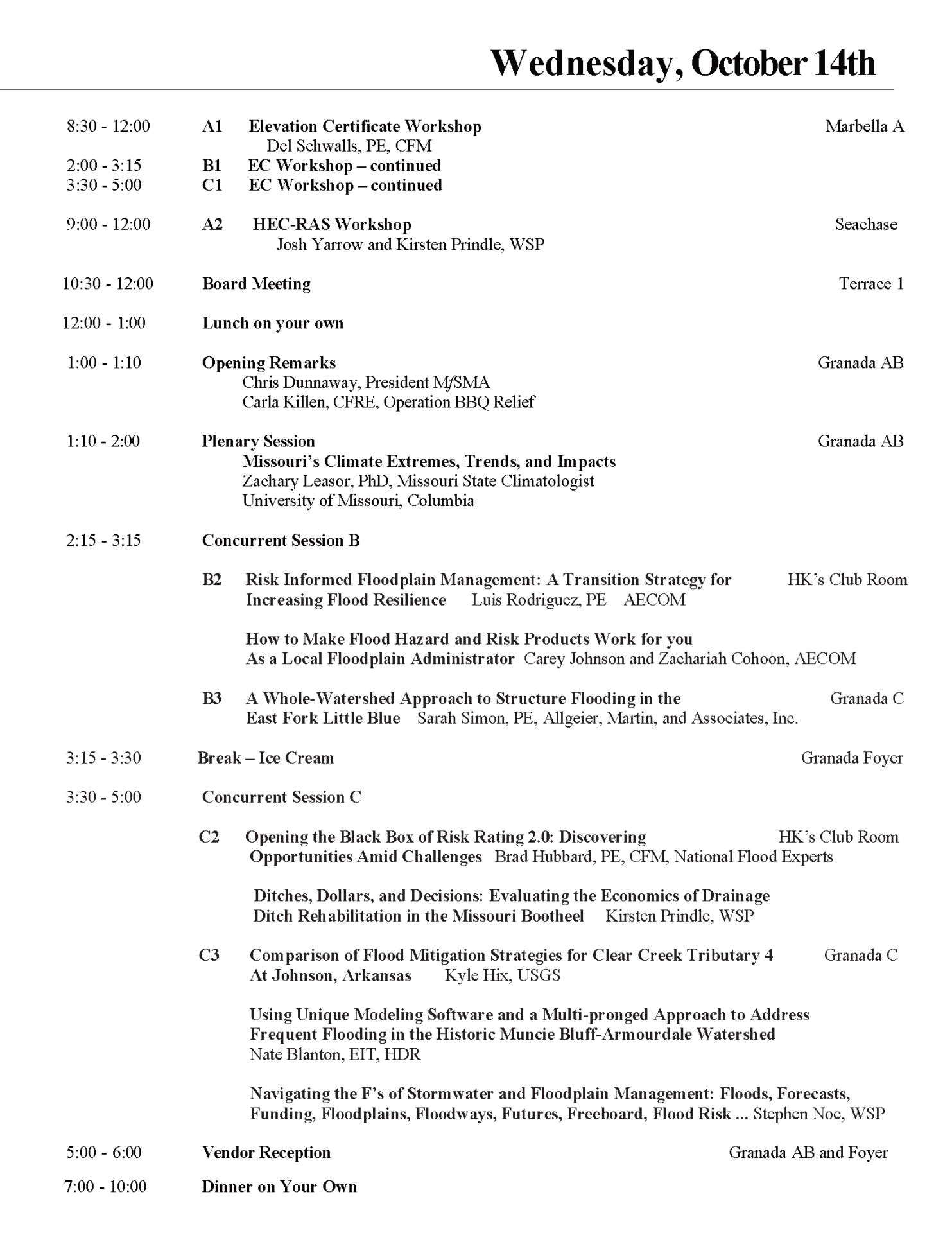
| A1 | 10/14/2026 | 9:00-12:00 | Del Schwalls, PE, CFM | Schwalls Consulting | 180 minutes | Elevation Certificate Workshop | |
| A2 | 10/14/2026 | 9:00-12:00 | Stephen Noe | WSP | 180 minutes | HEC-RAS Workshop | |
| Conference Opening | 10/14/2026 | 1:00-1:15 | Carla Killen |
Event Fundraising Specialist, Operation Barbeque |
15 minutes | Opening Session | |
| Plenary | 10/14/2026 | 1:15-2:00 | 60 minutes | Opening Session | |||
| B1/C1 | 10/14/2026 | 2:15-5:15 | Del Schwalls, PE, CFM | Schwalls Consulting | 3 Hours | Elevation Certificate Workshop (cont.) | |
| B2 | 10/14/2026 | 2:15 - 3:15 | Bradley Hubbard | National Flood Experts | 30 minutes | Opening the Black Box of Risk Rating 2.0: Discovering Opportunities Amid Challenges | Risk Rating 2.0 has reshaped U.S. floodplain management. Brad Hubbard (CEO, National Flood Experts) explores its complexities and gains, offering an optimistic outlook. Through real-world accounts, he demonstrates how FloCom decodes the new system's intricacies. By illuminating factors affecting premiums, FloCom transforms initial confusion and lack of transparency into deeper understanding, enhancing the accuracy and relevance of flood risk assessments for managers. |
| B2 | 10/14/2026 | 2:15 - 3:15 | Carey Johnson and Zachariah Cohoon | AECOM | 30 minutes | How to Make Flood Hazard and Risk Products Work for You as a Local Floodplain Administrator | This presentation demonstrates how flood modeling and mapping outputs can be leveraged to enhance community flood resilience. Participants will learn practical methods for accessing and applying regulatory and non-regulatory flood hazard and risk datasets. The session will highlight how these tools support a wide range of responsibilities, from hazard mitigation planning, emergency management, and permitting, to Letters of Map Change, community outreach, and CRS credit improvements. |
| B3 | 10/14/2026 | 2:15 - 3:15 | Sarah Simon, PE | Allgeier, Martin, and Associates, Inc. | 45 minutes | A Whole-Watershed Approach to Structure Flooding in the East Fork Little Blue | The EFLB watershed in Lee's Summit has multiple flooding hot spots, with homes flooding from interconnected local & riverine sources. So, the City decided to take a whole-watershed approach. Allgeier Martin created detailed hydrologic & hydraulic models to test solutions for downstream effects. Challenges included old, undersized storm systems, riverine flooding, and tight, utility-filled spaces. Creative solutions were required to keep each mitigation project from causing problems for the next. |
| Break | 10/14/2026 | 3:15-3:30 | Refreshments | ||||
| C2 | 10/14/2026 | 3:30 - 4:30 | Kirsten Prindle | WSP | 60 minutes | Ditches, Dollars, and Decisions: Evaluating the Economics of Drainage Ditch Rehabilitation in the Missouri Bootheel | As drainage infrastructure extends beyond its design life, measures must be taken to maintain a functioning system. To help drainage districts determine where they can get the best bang for their buck. An investigation of the benefits and costs of drainage ditch rehabilitation across multiple watersheds within the Bootheel of Missouri was performed. Risks like damage to buildings, crops, and roads were analyzed and weighed against the cost of rehabilitation to determine the value of a project. |
| C3 | 10/14/2026 | 3:30 - 4:30 | Kyle Hix | USGS | 30 minutes | Comparison of Flood Mitigation Strategies for Clear Creek Tributary 4 at Johnson, Arkansas | A two-dimensional rain-on-grid model of Tributary 4 in the Clear Creek basin in North-Central Washington County, Arkansas, was developed to assess the relative effectiveness of flood mitigation strategies. Five mitigation strategies were evaluated for a range of probabilistic precipitation events under existing and theoretical future basin conditions. The results highlight complex hydraulic interactions, identify critical factors in flood impacts, and inform mitigation strategy planning. |
| C3 | 10/14/2026 | 3:30 - 4:30 | Nate Blanton, EIT | HDR | 30 minutes | Using Unique Modeling Software and a Multi-pronged Approach to Address Frequent Flooding in the Historic Muncie Bluff-Armourdale Watershed (Kanas City, Kansas) | This watershed in KCK, faces stormwater challenges that can be attributed to frequent flooding from aging and undersized drainage systems. HDR worked w/ the UG and USACE to create detailed H&H analysis using StormWise. A plan was developed to reduce flood risk in frequent storm events. Detaining runoff, capacity improvements of the inlets & pipes of the system, and GSI were identified to mitigate inundation and collaborate with combined sewer separation in the area. |
| Vendors' Reception | 10/14/2026 | 5:00-6:00 | Refreshments | ||||
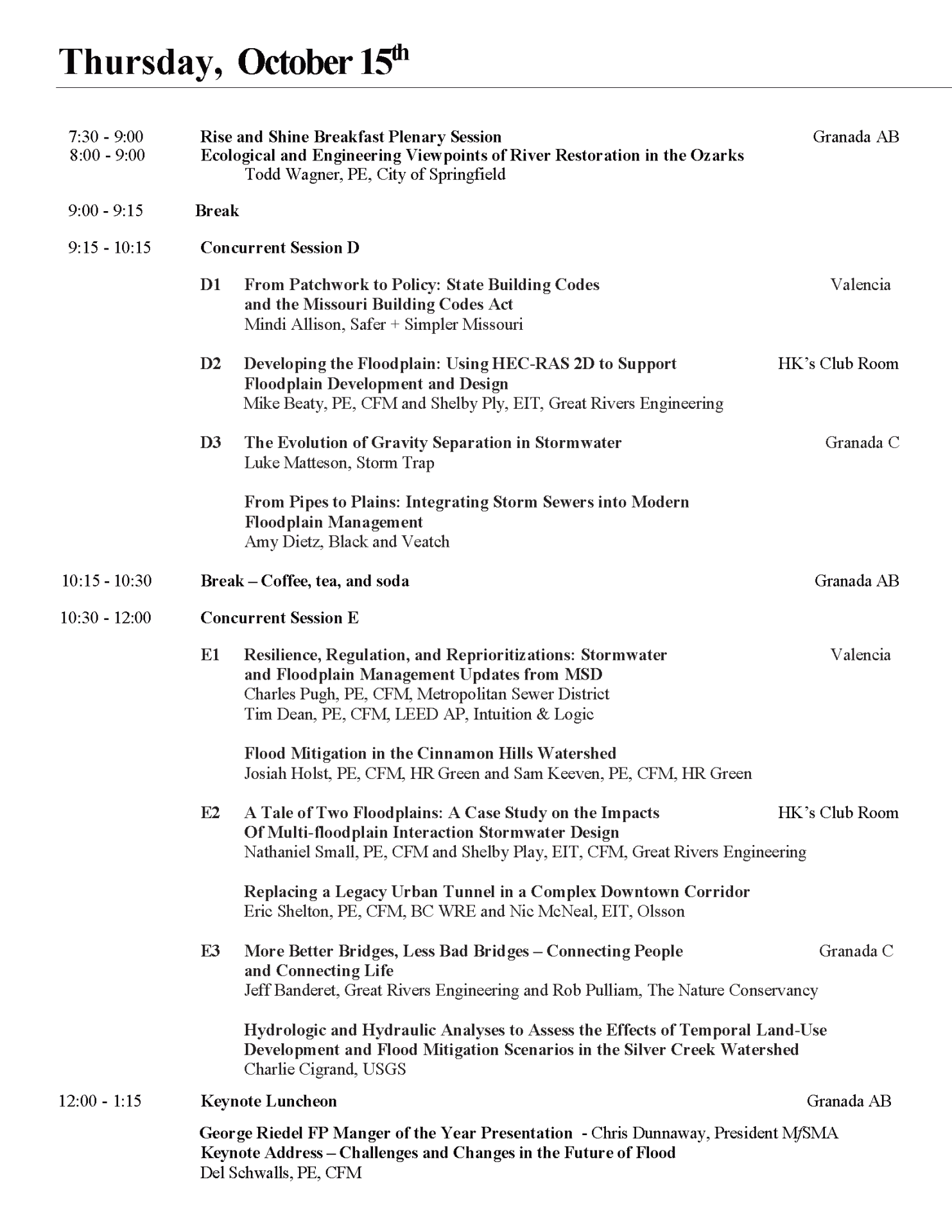
| Hot Breakfast | 10/15/2026 | 7:30-8:30 | |||||
| Plenary | 10/15/2026 | 8:00 - 9:00 | 60 minutes | Meeting Public Expectations vs Stormwater Reality | |||
| D1 | 10/15/1016 | 9:15 - 10:15 | Mindi Allison | Safer + Simpler Missouri | 45 minutes | From Patchwork to Policy: State Building Codes and The Missouri Building Codes Act | Across the country, 44 states have a state building code (including 7 of Missouri's neighbors), making it easier to know what the building rules and regulations are. Since Missouri has yet to adopt a state code, it is left to all of the jurisdictions across the state to adopt and update codes. This presentation will highlight both (1) the ways that a local vs state adoption of codes impact development and construction, and (2) a legislative solution in the Missouri State Building Codes Act. |
| D2 | 10/15/2026 | 9:15 - 10:15 | Mengye Chen | University of Oklahoma, Yang Hong, University of Oklahoma | 60 minutes | CREST modeling family and operational flood monitoring | This presentation reviews the evolution of the CREST distributed hydrological model from satellite-driven origins to AI-enabled systems. CREST simulates coupled runoff and routing using remote sensing data across scales. Its extensions (EF5, iMAP, iCRESLIDE, CREST-VEC) support flood forecasting and hazard modeling. Recent advances include CREST-AI and agent-based automation, highlighting a shift toward scalable, intelligent hydrological modeling. |
| D3 | 10/15/2026 | 9:15 - 10:15 | Luke Matteson | StormTrap | 30 minutes | The Evolution of Gravity Separation in Stormwater | Gravity settling has evolved from simple basins to advanced hydrodynamic devices, improving stormwater treatment and clarifying key performance factors. Standardized testing, such as NJDEP HDS protocols, ensures consistent evaluation and comparability. National efforts led by NMSA/STEPP aim to unify standards, with ASTM collaboration advancing reliable, industry-wide methods for assessing device effectiveness and supporting broader adoption. |
| D3 | 10/15/2026 | 9:15 - 10:15 | Amy Dietz | Black and Veatch | 30 minutes | From Pipes to Plains: Integrating Storm Sewers into Modern Floodplain Management | This workshop will go through the new Elevation Certificate (released in 2023) section by section to help participants verify forms are being completed correctly by both licensed professionals and local community officials. Specific focus will be applied to building diagrams since they are very important in floodplain management at the local level and insurance rating by the NFIP. The workshop will also cover the proper steps to reviewing ECs for compliance with floodplain management regulations and for credit under the Community Rating System. We will also discuss the two new sections of the EC form, created to help homeowners document building characteristics that could potentially qualify them for insurance discounts without having to hire a surveyor. |
| Break | 10/15/2026 | 10:15-10:30 | Refreshments | ||||
| E1 | 10/15/2026 | 10:30 - 12:00 | Yeferson Parra, CFM and Trey McCarter | City of St. Louis | 45 minutes | Beyond the SFHA: Methodologies for Addressing Flood Risk During the Environmental Review Process for HUD-Assisted Projects in the City of St. Louis | The Westport Branch Green Stormwater Infrastructure Project is a water quality improvement project that used 2D modeling to evaluate design alternatives that examined flood mitigation and water quality treatment optimization. The City of Springfield identified three underutilized green spaces that could be used to improve water quality by capturing and treating the most frequent storm events. The design team collaborated closely with the City on the design concepts during design workshops to select a preferred design alternative. A 2D watershed model of the drainage areas was used to establish baseline existing conditions and simulated performance of proposed improvement alternatives. The 2D model was instrumental in eliminating a costly flood mitigation channel realignment alternative that the 2D model showed no improvement to the flood risk due to downstream constraints outside of the project area. Instead, the City moved forward with purchasing the affected property to eliminate the flood risk and to expand the green infrastructure for additional water quality improvements. The green infrastructure designs at three different sites use an integrated design approach that is optimizing the water quality treatment volume while working within site constraints |
| E1 | 10/15/2026 | 10:30 - 12:00 | Pinar Turker, Ph.D. | St. Charles County | 30 minutes | Beyond Fragmentation: Building an Integrated Disaster Recovery System in St. Charles County | After a federal disaster declaration, St. Charles County received funding in 2023. The flood is seven years old. The program is still running. This is the third in a series documenting St. Charles County's experience building an integrated disaster recovery system. This presentation names the gap between program design and real outcomes, and discusses what strategies practitioners can use to build coherence within a system not designed for it. |
| E2 | 10/15/2026 | 10:30 - 12:00 | Nathaniel Small, PE, CFM, Shelby Ply, EI, CFM | Great River Engineering | 30 minutes | A Tale of Two Floodplains: A Case Study on the impacts of Mult-floodplain interaction stormwater design | Development within large watersheds has increased runoff entering legacy stormwater systems, creating bottlenecks where undersized structures cannot convey peak flows. Ponding and backwater effects near large waterways can worsen flooding when downstream stages remain elevated. This case study from the City of Brunswick examines drainage improvements near the Grand River using hydraulic modeling to reduce flooding while meeting railroad constraints. |
| E2 | 10/15/2026 | 10:30 - 12:00 | Eric Shelton, PE, CFM, BC.WRE, Nic McNeal, EI, Aaron Weaver, PE | Olsson | 45 minutes | Replacing a Legacy Urban Tunnel in a Complex Downtown Corridor | The City of Joplin, Missouri is advancing a stormwater project to replace the aging Old Willow Branch box culvert beneath downtown buildings. Alternatives were evaluated to relocate the culvert to more accessible corridors while maintaining hydraulic performance. PCSWMM modeling assessed capacity and flood risk. The selected concept improves reliability, reduces flood risk, and balances constructability with dense urban constraints. |
| E3 | 10/15/2026 | 10:30 - 12:00 | Jeff Banderet and Rob Pulliam | Great River Engineering, The Nature Conservancy | 45 minutes | More Better Bridges, Less Bad Bridges - connecting People and Connecting Life | Missouri has nearly 74,000 miles of county roads that require stream crossings. Ozark counties often build low water slab crossings because they are cheap compared to engineered bridges. The Nature Conservancy (TNC) created a small bridges team designed to meet the transportation needs of counties and movement of aquatic life. TNC contracted with an engineering firm to develop standardized bridge plans which TNC is giving to Ozark counties to help them build better bridges. |
| E3 | 10/15/2026 | 10:30-12:00 | Charlie Cigrand | USGS | 30 minutes | Hydrologic and Hydraulic Analyses to Assess the effects of Temporal Land-Use Development and flood Mitigation Scenarios in the Silver Creek Watershed | The Silver Creek watershed, located immediately east of the St. Louis metropolitan area, has experienced land-use changes. To analyze a change in hydrologic conditions, a basin-wide hydrologic model was used to quantify peak flows associated with temporal land-use datasets consisting of historical, current, and projected future conditions. At a localized scale, a hydraulic model was used to assess flood volume storage as a viable flood mitigation strategy for reoccurring flood events. |
| Keynote Luncheon | 10/15/2026 | 12:00-1:15 | |||||
| Plenary | 10/15/2026 | 12:00 - 1:15 | Del Schwalls, PE, CFM | Schwalls Consulting | 30 minutes | Keynote Luncheon Address | |
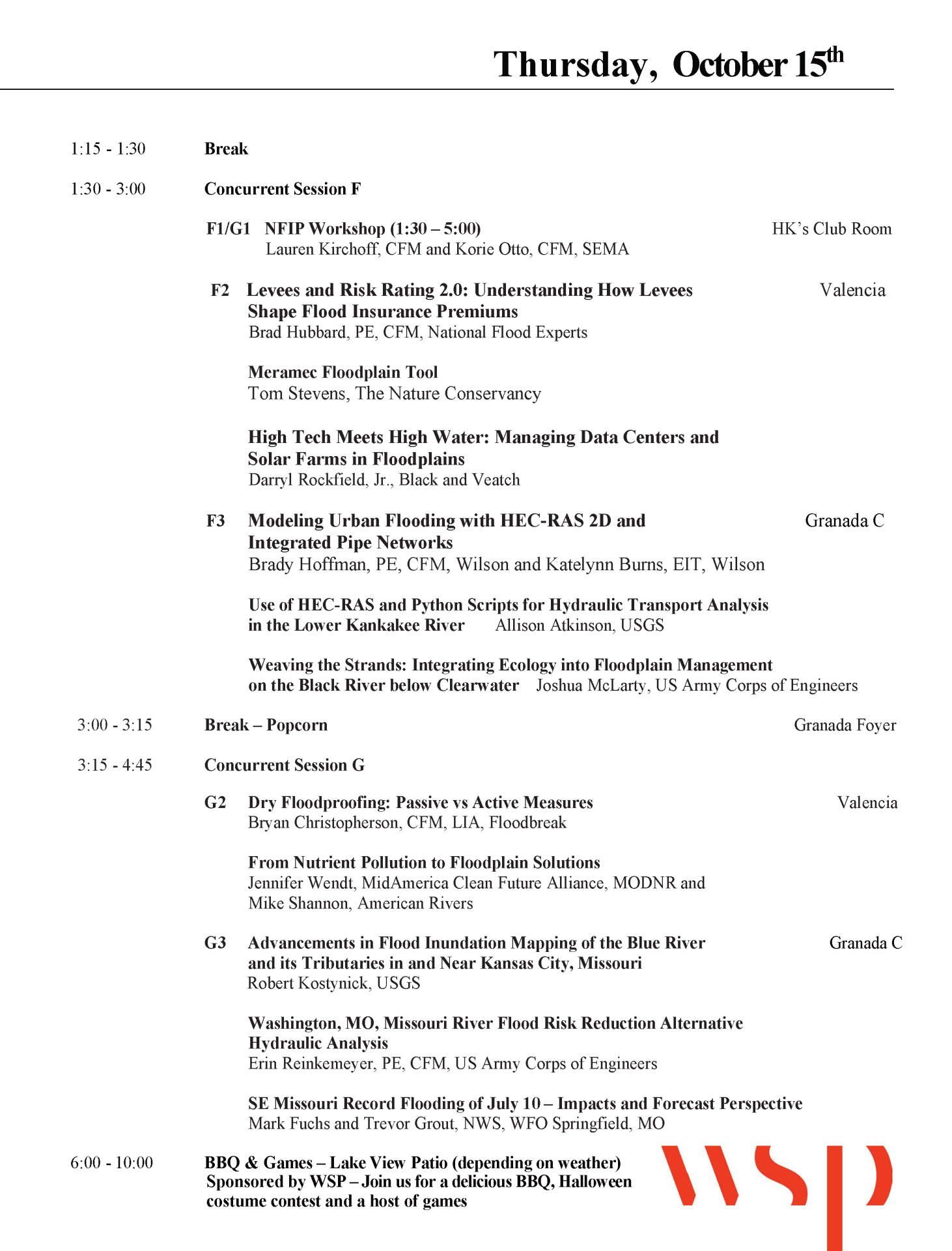
| F1/G1 | 10/15/2026 | 1:30-4:45 | Lauren Kirchhoff, CFM and Korie Otto, CFM | SEMA | 180 minutes | NFIP Workshop | |
| F2 | 10/15/2026 | 1:30 - 3:00 | Bradley Hubbard | National Flood Exoerts | 30 minutes | Levees and Risk Rating 2.0: Understanding How Levees Shape Flood Insurance Premiums | Under FEMA's Risk Rating 2.0, levees influence flood insurance premiums in ways that aren't always intuitive, even to experienced floodplain managers and engineers. The relationship between a levee's credited protection level, the properties it influences, and what those property owners actually pay is more nuanced than a simple in/out-of-floodplain determination. This session breaks down how RR2.0 prices levee-influenced risk, what variables drive premium outcomes for properties behind levee systems, and why many Midwest communities may be carrying hidden insurance pressure they don't fully see. For communities with legacy levee systems that aren't receiving full credit from FEMA, the gap between actual and credited protection has real financial consequences for constituents and a correctable one. Attendees will leave with a working understanding of how levees factor into RR2.0 pricing, where to look for under-credited systems, and what engineering and data pathways exist to address them. The session draws on analysis from National Flood Experts, including work through our FloCom platform, which integrates levee performance and insurance data to identify where gaps are largest and intervention matters most. |
| F2 | 10/15/2026 | 1:30 - 3:00 | Tom Stevens | The Nature Conservancy | 30 minutes | Meramec Floodplain Tool | The Nature Conservancy has recently rebuilt their Meramec Floodplain Tool, a free GIS application designed to use water quality, habitat, and population data to identify critical opportunities for floodplain protection and restoration in the Meramec River basin. This presentation will include an overview and demonstration of this tool and will show how it can be used for geospatial prioritization of potential floodplain project locations. |
| F2 | 10/15/2026 | 1:30 - 3:00 | Darryl Rockfield, Jr. | Black & Veatch | 30 minutes | High Tech Meets High Water: Managing Data Centers and Solar Farms in Floodplains | The rapid expansion of data centers and solar sites present new challenges and opportunities for communities tasked with balancing economics, resilience, and risk reduction. Data centers and solar farms are commonly being sited in or near flood-prone areas due to land availability, proximity to infrastructure, and cooling/grading requirements. This presentation will explore these emerging land uses and highlight considerations for informed floodplain management. |
| F3 | 10/15/2026 | 1:30 - 3:00 | Brady Hoffman, PE, CFM and Katelynn Burns, EIT | Wilson | 30 minutes | Modeling Urban Flooding with HEC-RAS 2-D and Integrated Pipe Networks | When the pipes cannot keep up, the streets take over. Effective stormwater design requires understanding both surface and subsurface system interactions. This analysis uses 2D HEC RAS with pipe networks to diagnose and solve urban drainage challenges in a residential watershed. Existing conditions show clear capacity shortfalls and roadway and residential flooding during storms. Strategic infrastructure upgrades improve conveyance of the 10-year event and reduce flood risk at the surface. |
| F3 | 10/15/2026 | 1:30 - 3:00 | Allison Atkinson | USGS | 30 minutes | Use of HEC-RAS and python scripts for hydraulic transport analysis in the Lower Kankakee River | Operators of a power plant in Illinois have recorded grassing events where macrophytes accumulate near the intake. This study examined how riverine hydraulics may contribute to events. HEC-RAS modeling and Python scripting were used to examine results at the cell face level. Years with low flows are more likely to have an event, but hydraulics aren't the only causal factor. This study indicates a need for correlative modeling techniques, like machine learning, to be incorporated into studies. |
| F3 | 10/15/2026 | 1:30 - 3:00 | Joshua McLarty | US Army Corps of Engineers | 30 minutes | Weaving the Strands: Integrating Ecology into Flood Management on the Black River below Clearwater | The Sustainable Rivers Program (SRP) is an effort by the U.S. Army Corps of Engineers (USACE) to determine environmental flow requirements for rivers, then create operating plans for dams that incorporate these flows. The Black River SRP evaluates Clearwater Lake and the downstream environmental/ecological impacts of USACE dam releases. |
| Break | 10/15/2026 | 3:00-3:15 | Refreshments | ||||
| G2 | 10/15/2026 | 3:15 - 4:45 | Bryan Christopherson, CFM, LIA | Floodbreak | 60 minutes | Dry Floodproofing: Passive vs Active Measures | Examine dry floodproofing strategies, with a focus on the differences between passive & active flood protection and their impact on life safety, Success. Active systems require manual deployment prior to flood, introducing risk due to reliance on personnel, timing, and preparedness. In contrast, passive flood protection systems deploy automatically in response to rising water levels, eliminating the need for human intervention or power and providing continuous, reliable protection. |
| G2 | 10/15/2026 | 3:15 - 4:45 | Caran Hanks | MidAmerica Clean Future Alliance, MODNR | 45 minutes | Advancing Water Quality Through Community Engagement & Education: One Water Missouri Initiative | The One Water Missouri initiative connects soil health, stormwater, and water quality through community engagement and cross-sector collaboration. This session highlights efforts to reduce nutrient runoff and Gulf hypoxia through partnerships with farmers, conservation professionals, and organizations promoting BMPs such as cover crops and soil health practices. Attendees will gain practical outreach |
| G3 | 10/15/2026 | 3:15 - 4:45 | Robert Kostynick | USGS | 30 minutes | Advancements in Flood Inundation Mapping of the Blue River and its Tributaries in and Near Kansas City, Missouri | The U.S. Geological Survey (USGS), in cooperation with the City of Kansas City, Missouri, has developed eight digital flood inundation maps (FIMs) that include 35.5 miles of the Blue River, 4.4 miles of Brush Creek and 2.9 miles of Indian Creek, in and near Kansas City, Missouri. FIMs have been constructed utilizing two-dimensional hydraulic models. Temporal information in the form of flood travel times between USGS gage locations was determined to aid downstream response times. |
| G3 | 10/15/2026 | 3:15-4:45 | Erin Reinkemeyer, PE,CFM | US Army Corps of Engineers | 30 minutes | Washington, MO Missouri River Flood Risk Reduction Alternative Hydraulic Analysis | Washington, MO and adjacent areas are located within the Missouri River floodplain and have a history of flooding. Recent flood events have resulted in notable drainage damage to public infrastructure, access issues, and sustained impacts to inundated property. The Washington, MO FPMS project serves as a case study highlighting opportunities under the FPMS program to improve understanding of flood risk and serve as a foundation for future alternative and floodplain analysis. |
| Barbeque | 10/15/2026 | 6:00-? | Food and Halloween Costume Contest | Sponsored by WSP | |||
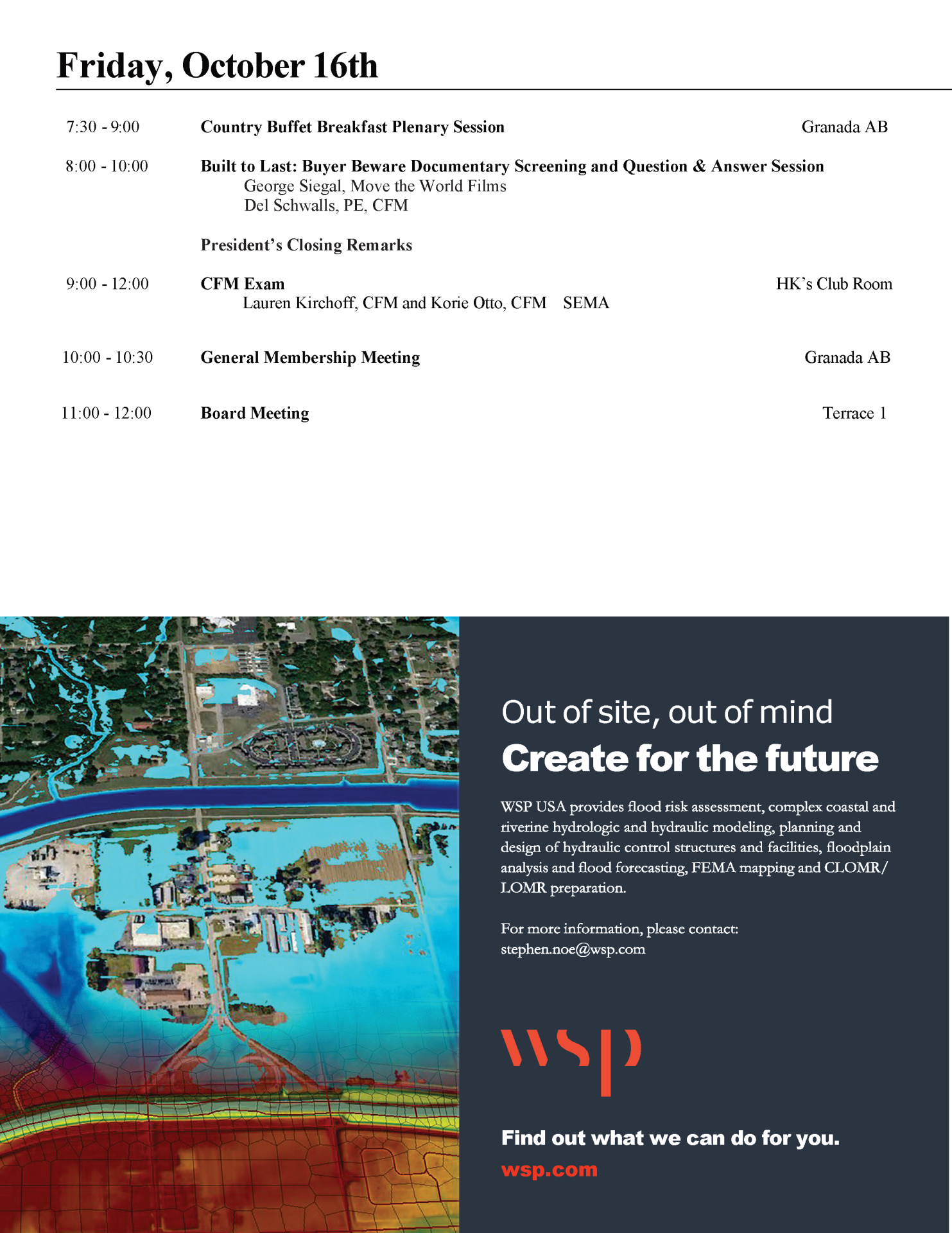
| Hot Breakfast | 10/16/2026 | 7:30-8:30 | |||||
| H1 | 10/16/2026 | 9:00-12:00 | Lauren Kirchhoff, CFM and Korie Otto, CFM | SEMA | 180 minutes | CFM Exam | |
| Plenary | 10/16/2026 | 8:00-10:00 | George Siegal, Del Schwalls, PE, CFM | Move the World Films and Schwalls Consulting | 120 minutes | Built to Last: Buyer Beware Screening | Introductory by George Siegal, director of the documentary, :"Built to Last: Buyer Beware", followed by a question and answer period. |
| H2 | 10/16/2026 | 10:00-10:30 | MfSMA General Membership Meeting | ||||
| Conclusion | 10/16/2026 | 10:30-11:30 | MfSMA Board Meeting | ||||